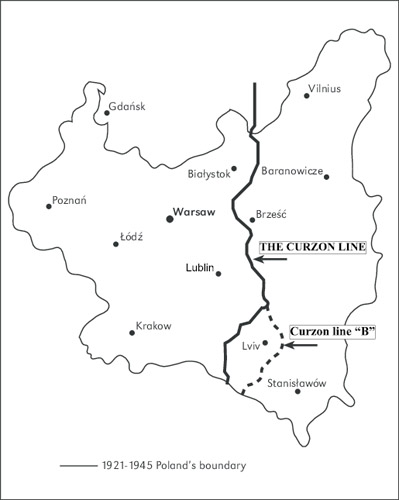
Curzon Line
Curzon Line. Conventional designation of a line running through Hrodna, Yalivka, Nemyriv, Brest, Dorohusk, Ustyluh, east of Hrubeshiv, through Kryliv, west of Peremyshl, to the Carpathian Mountains, which was to constitute the eastern border of Poland, including Poland's border with Ukraine. The Curzon Line was first designated as Poland's eastern border by the Allied Supreme Council on 8 December 1919. In July 1920, during the Soviet advance on Warsaw, the same line was proposed by the British foreign secretary, G. Curzon (hence the name ‘Curzon Line’), as the border between Poland and Soviet Russia. The Peace Treaty of Riga between Poland and the Soviet republics (1921) gave Poland some 135,000 sq km of territory east of the Curzon Line. On 23 August 1939 the Curzon Line was accepted (with corrections in favor of the USSR) as the German–Soviet boundary in the pact between Germany and the Union of Soviet Socialist Republics. Finally, the Curzon Line was accepted as the Polish–Soviet boundary at the Yalta Conference (February 1945), this time with corrections in favor of Poland. It was later confirmed by a treaty between the USSR and Poland, signed in Moscow on 16 August 1945 (see also Zakerzonnia). In 1951, by mutual agreement between Poland and the USSR, further frontier adjustments were made.
BIBLIOGRAPHY
Abramson, A. Die Curzon-Linie, das Grenzproblem Sowjetunion–Polen (Zürich 1945)
Yakemtchuk, R. La ligne Curzon et la IIe guerre mondiale (Louvain 1957)
Vasyl Markus
[This article originally appeared in the Encyclopedia of Ukraine, vol. 1 (1984).]
