Central Upland
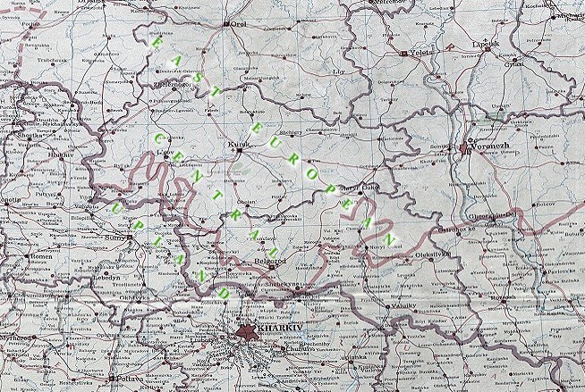
Central Upland (Serednia vysochyna) (usually known as the Central Russian Upland and sometimes as the East European Central Upland). An extensive upland in the central part of Eastern Europe, stretching from the north and the northwest (from the Oka River and the line Kaluga-Riazan) towards the southeast to the Donets River, whose valley is sometimes designated as the Donets Lowland. In the east the upland borders on the Oka-Kama Lowland and in the west on the Dnipro Lowland. It is up to 1,000 km long and 500 km wide. The greater part of the upland lies within the borders of Russia. Only a small part of it lies on Ukrainian ethnic territory within the borders of Ukraine (parts of Sumy oblast, Kharkiv oblast, and Luhansk oblast) and within the Russian Federation (the southern parts of Belgorod oblast and Voronezh oblast and the edges of Kursk oblast and Rostov oblast). The Central Upland is an undulating plateau with an average elevation of 230–250 m (293 m at its highest point). The plateau is dissected to a depth of 100 and even 150 m by river valleys, ravines, and gullies. Basically, the upland is built of Precambrian deposits of the crystalline Voronezh Massif, which in the southwest descends to the Dnipro-Donets Trough. Most of the Voronezh Massif is covered with thin layers (up to 150 m) of sedimentary deposits of the Devonian, Jurassic, Cretaceous, and Paleogene periods. In the southeast along the Don River between the cities of Bohuchar and Pavlovsk the crystalline layers come to the surface. On all sides of the upland the Precambrian deposits descend far below the sedimentary layers. A small part of the upland in the northwest was covered with a glacier during the Dnipro glaciation. Today almost all of the upland is covered with loess and loessial loams. Rivers that arise in the Central Upland flow into the Black Sea, the Caspian Sea, and the Sea of Azov. The larger part of the upland belongs to the forest-steppe belt, but the southwestern part belongs to the belt of mixed forests and the southeastern part to the steppe belt.
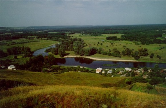
The Ukrainian part of the Central Upland, consisting of the southwestern slope of the upland and its southwest branch and covering an area of about 80,000 sq km, corresponds to the southwestern slopes of the Voronezh Massif, which are covered with thick layers of chalk (particularly white chalk, which comes to the surface in exposed areas) and thin layers of Paleogene and Anthropogene deposits. All these layers are soft and subject to erosion. The upland is a gently sloping loess plain, denudated by erosion, that is densely dissected. Absolute elevations diminish in the southwestern direction, which defines the flow of the following rivers: the tributaries of the Dnipro River—the Seim River, the Sula River, the Psol River, the Vorskla River, etc—and of the Donets River—the Udai River, the Nezhehol River, the Oskil River, the Aidar River, the Derkul River, the Kalytva River, etc. The eastern part of the upland slopes towards the east to the Don River and is dissected by its tributaries—the Tykha Sosna River, the Chorna Kalytva River, the Osered River, the Tohuchivka River, etc. The river valleys are usually wide (up to 6 km) and deep. As in the Poltava Plain the right-bank parts of the valleys are generally steep, complicated by slides and covered by forests or brush. They are dissected by short, deep, sharply incised ravines. The left-bank sides of the valleys are sloping and have three to four terraces, of which the lower are covered mostly with sand and the higher with loess. They are infrequently dissected by long ravines and shallow gullies with sloping sides. In general, the ravines and gullies in the upland are more prevalent than in other Ukrainian territories. Their density is 1–2 km per sq km, and the dissection that results from them reaches 10–30 percent of the area (it is highest in the southeastern part between the Oskil and Don rivers and the Khopor River). Deforestation of the upland and plowing of the steppes have contributed to the growth of the gullies and have brought about a catastrophic increase in the amount of non-arable land.
In the generally uniform landscape of the Central Upland the high right banks of rivers, built mostly of chalk layers, constitute the more picturesque regions. This is particularly true of the right bank of the Don River, which is known as Donske Bilohiria (the Don White Hills, elevation 242 m), and the densely dissected Kalach Upland in the southeast. In the southwestern part of the Sumy region karst topographical features are common. Moraine and sandur plains are also found there. Generally, this part of the upland forms a transition to the northern part of the Dnipro Lowland and Left-Bank Polisia, which is sometimes known as Siverianian Polisia. On the swampy terraces of rivers eolian forms are sometimes found.
The rivers of the upland, except for the Don River and the Donets River, are small, and some of them dry out in the summer. Numerous lakes and marshes are found in the floodplains of the rivers.
The climate of the upland is the most continental in Ukraine, and the winters are the coldest. The average annual temperature is 6°C in the north and 8.5°C in the south; the average January temperature is -7°C in the southwest and -9.5°C in the northeast; and the average July temperature is 19°C in the northwest and 22°C in the southeast. The average difference in temperature between the coldest and warmest month increases from 26°C in the northwest to 29°C in the southeast. The average annual precipitation varies from 500 mm in the northwest to 400 mm in the southeast. Seventy-five percent of the precipitation comes in the summer months, when downpours are common. The winters are remarkably stable, and the summers are dry with frequent dry winds.
The soils and vegetation change from the north-northwest to the south-southeast. Podzolized soils, podzolized chernozems, and dark gray, gray, and light gray podzolized soils are prevalent north of the Seim River. In the forest belt soddy podzolic sandy soils are also found. In the rest of the forest-steppe the deep, low-humus chernozems are common. In the steppes the ordinary low- humus chernozems prevail. Meadow chernozems, sandy soils, and swampy soils are found in the river valleys.
Approximately half of the Central Upland lies in the forest-steppe and steppe belts. The rest lies in the forest belt. Today scarcely 6 percent of this belt is covered with forest. Most of the forests are mixed (pine, oak, birch); some are pine. A significant part of the upland consists of dry and flood meadows and swamps. In the forest-steppe belt forests occupy about 10 percent of the area, mostly in the northwest and the river valleys. Oak forests with an admixture of maple, ash, and linden are most common, while on the sandy river terraces pine forests with oak, alder, willow, etc prevail. Remnants of the grassy, colored, broadleafed steppe have survived only on the ravine slopes. The large Shypovyi Forest (32,000 ha) near Buturlynivka is partly under state protection. Yama Steppe in southern Voronezh oblast (near Staryi Oskil) is a nature preserve. Forests cover 3 percent (mostly on the sandy terraces of the Donets) of the colored fescue-feather-grass steppe belt. Some of the steppe vegetation has survived on the steep slopes of gullies and ravines, on the small tracts of virgin steppe, and on reserves such as the Striltsivskyi Steppe.
(For population and economy see Slobidska Ukraine.)
BIBLIOGRAPHY
Bondarchuk, V. Heomorfolohiia URSR (Kyiv 1949)
Chyzhov, M. Ukraïns'kyi lisostep (Kyiv 1961)
Popov, V.; Marinich, A.; Lan'ko, A. (eds). Fiziko-geograficheskoe raionirovanie Ukrainskoi SSR (Kyiv 1968)
Sovetskii Soiuz: Geograficheskoe opisanie v 22-kh tt. Tsentral'naia Rossiia (Moscow 1970)
Marynych, O.; Lan'ko, A.; Shcherban, P.; Shyshchenko, P. Fizychna heohrafiia Ukraïns'koï RSR (Kyiv 1982)
Volodymyr Kubijovyč
[This article originally appeared in the Encyclopedia of Ukraine, vol. 1 (1984).]

