Territory, national and ethnic
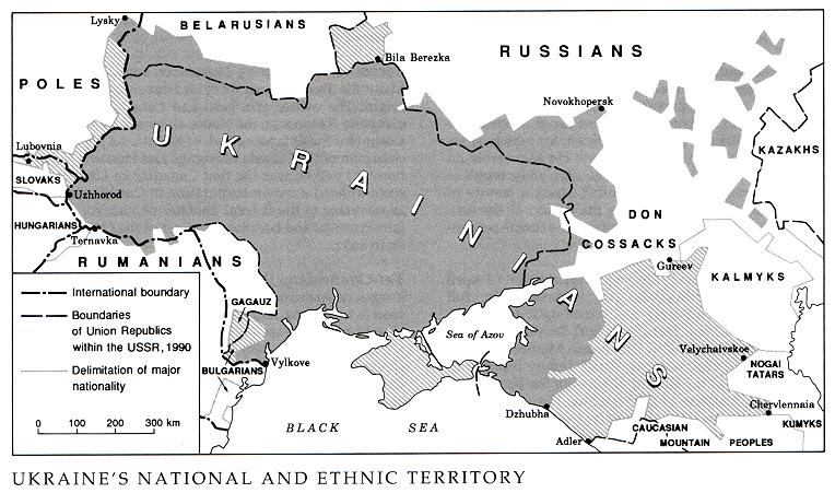
Territory, national and ethnic. Ethnic territory is the territory inhabited compactly by a given people or nation, such as by Ukrainians; national territory is the territory held by a given nation-state. The dimensions of the Ukrainian national and ethnic territory have undergone many changes in the past millennium. Whereas in the north, west, and southwest the changes were relatively small, in the south and southeast, along the steppe frontier and the Black Sea coast, the fluctuations were dramatic. At the beginning of the 13th century the Cumans pushed back from the Black Sea the proto-Ukrainian tribes of the Ulychians and Tivertsians, who lived between the Dnister River and the Dnipro River, and thereby reduced the Ukrainian ethnic territory to about 400,000 sq km. The Tatar-Mongol invasion (1239) reduced the Ukrainian ethnic territory in the steppe and most of the forest-steppe, and left a little over 250,000 sq km, mostly in the forest belt, under the control of Ukrainian princes. Under the rule of the Grand Duchy of Lithuania the Ukrainian ethnic territory had nearly doubled by the end of the 14th century, but it contracted again, to some 280,000 sq km, at the end of the 15th century, when the Tatars resumed their attacks. Intensive Ukrainian colonization, which began at the end of the 16th century in the forest-steppe on the right bank of the Dnipro River, soon expanded eastward to Left-Bank Ukraine, Slobidska Ukraine, and the Zaporizhia. As a result the Ukrainian ethnic territory had increased to about 450,000 sq km by the mid-18th century. In the 19th century, after the steppe, the Black Sea littoral, and the Kuban Lowland had been settled by Ukrainians, the Ukrainian ethnic territory reached nearly 700,000 sq km. The eastern Kuban, the Terek region, and the Stavropol region were settled by Ukrainians and Russians. Thus a large mixed Ukrainian-Russian ethnic territory arose to the southeast of the Ukrainian ethnic territory. Although it expanded to the south and east, the Ukrainian ethnic territory lost small areas in the west to encroaching settlements of Poles, Slovaks, and Hungarians.
The first accurate estimates of the size of the Ukrainian ethnic territory were made at the beginning of the 20th century, following the publication of the results of the first Russian population census of 1897. By counting all the counties with a rural population over 50 percent Ukrainian, Oleksander Rusov computed the size of the Ukrainian ethnic territory within the Russian Empire to be 576,600 sq km. At the same time Volodymyr Okhrymovych (for Galicia and Bukovyna) and Stepan Tomashivsky (for Transcarpathia) calculated the Ukrainian ethnic territory within Austria-Hungary to be 74,000 sq km. In 1918 Myron Korduba delineated the Ukrainian ethnic territory even more precisely: the part within the former Russian Empire was 664,600 sq km, and the part within Austria-Hungary, 74,500 sq km. Stepan Rudnytsky estimated the Ukrainian national territory at two levels: its minimal area was 905,000 sq km, and its maximal area (which included the mixed and sparsely settled territories to the southeast), 1,056,000 sq km.
On the basis of the first Soviet census in 1926 and other data, Volodymyr Kubijovyč estimated the Ukrainian ethnic territory at 930,500 sq km, including the predominantly Ukrainian part of 718,300 sq km, and the mixed part of 212,200 sq km (eastern Subcaucasia, the Crimea, and the northern Chernihiv region, Kholm region, and Podlachia).
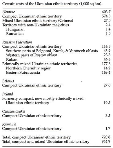
After the Second World War the compact Ukrainian ethnic territory diminished in the west as a result of the forced resettlement of Ukrainians from lands assigned to Poland (about 19,500 sq km; see Operation Wisła). The dispersion of Ukrainians throughout the USSR and their Russification outside the Ukrainian SSR also contributed to the diminishment of the Ukrainian ethnic territory. Even within the Ukrainian SSR, the Donets Basin has evolved into a mixed territory, because of the influx of Russians in the cities. The present constituents of the Ukrainian ethnic territory are listed in the table.
BIBLIOGRAPHY
Rusov, A. ‘Karta rasseleniia ukrainskogo naroda,’ Ukrainskii vestnik, 1906
Tomashivs'kyi, S. ‘Etnohrafichna karta Uhors'koï Rusy,’ Stat'i po slavianovedeniiu, vol 3 (Saint Petersburg 1910)
Korduba, M. Terytoriia i naseleniie Ukraïny (Vienna 1918)
Rudnyts'kyi, S. Ukraine: The Land and Its People (New York 1918)
———. Ohliad natsional’noï terytoriï Ukraïny (Berlin 1923)
Kubiiovych, V. Terytoriia i liudnist' ukraïns'kykh zemel' (Lviv 1935)
———. Heohrafiia ukraïns'kykh i sumezhnykh zemel' (Cracow–Lviv 1943)
Ihor Stebelsky
[This article originally appeared in the Encyclopedia of Ukraine, vol. 5 (1993).]


