Podlachia
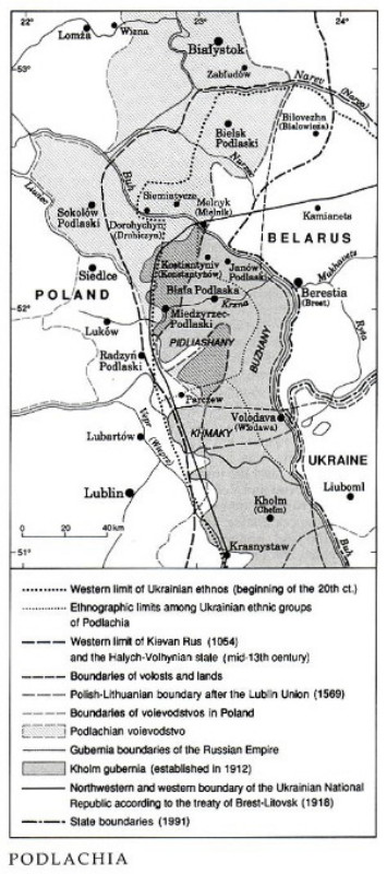
Podlachia (Ukrainian: Підляшшя, Pidliashshia; Polish: Podlasie). (Map: Podlachia.) A historical-geographical region along the middle stretch of the Buh River between the Kholm region in the south and the Narva River (the Belarus border) in the north and between Mazovia in the west and Volhynia and Polisia in the east. A part of the region consists of the Podlachian Lowland.
The Ukrainian name is derived from the word liakh ‘Pole’ (see Liakhy) and means ‘near Poland,’ whereas the Polish name is derived from las ‘forest,’ and means ‘near the forest.’ The name was first used in 1520 to designate Podlachia voivodeship, which extended at that time as far north as the sources of the Borba River. In the 19th century the name was applied generally to the part south of the Buh River and within the Congress Kingdom of Poland. The northern part of Podlachia, approx 2,700 sq km, constituted Bielsk Podlaski county in Hrodna gubernia. Southern Podlachia was often assigned to the Kholm region, because it lay within Kholm eparchy and (from 1912) within Kholm gubernia. The region had an area of approx 5,350 sq km and included Biała Podlaska, Volodava, and Kostiantyniv (Konstantynów) counties.
Because of its peripheral location Podlachia did not develop strong ties with other parts of Ukraine or a sharp sense of national identity. In the northern part the national distinctions between Ukrainians and Belarusians did not crystallize. Podlachia's proximity to the Polish heartland facilitated Polish expansion into the region. Flanked by Prussia on one side and the marshlands of Polisia on the other, Podlachia served as a corridor between Poland and Lithuania (the Warsaw–Vilnius route), Belarus, and Russia.
Physical geography. The geological foundation of the region consists of white chalk, which comes to the surface only near Melnyk and Volodava, in the Buh River Valley. The chalk is overlain with thick layers of glacial and alluvial deposits and here and there with thin Paleogene deposits. The landscape is typically a uniform plain. The Bielsk Podlaski, Dorohychyn, and Siedlce–Janów uplands, which reach an elevation of 200 m, are separated by broad river valleys formed by meltwaters and covered with thick alluvial deposits. The rivers are sluggish and lined with marshes. The highest parts of the region consist of terminal moraines: a northern belt runs from Siedlce through Melnyk to Vysoke, and a southern belt, from Lubartów to Volodava. Southeastern Podlachia, west of Volodava, with its marshes, peat bogs, sandy soils, and numerous small lakes, resembles Polisia in landscape and is known as Volodava Polisia. The most varied topography in all Podlachia is found in the Buh River Valley, which cuts deeply (up to 80 m) into the elevated plains. Podlachian soils are poor, mostly gray loamy or gray sandy soils and sometimes bog soils. The rivers draining the region, the Buh River with its tributaries (the Volodavka River, the Krzna River, the Mukhavets River, the Nurzec River, the Narva River, and the Lisna River) and the Vepr River (or Wieprz River), empty into the Vistula River.
Podlachia has a transitional climate between a continental and an oceanic one. Winters are mild (the average January temperature is between –3.5 °C and –4.5 °C), and summers are cool (the average July temperature is between 18 °C and 18.5 °C). The spring and the fall are long. Temperatures dip below the freezing point for 60 to 80 days of the year, and snow cover lasts for 80 to 100 days. The annual precipitation is approx 500 to 600 mm. The vegetation is typical of the northern forest belt, although the southwestern part of Podlachia borders on the Central European forest belt. The eastern limit of the beech, spruce, larch, and hornbeam and the southwestern limit of the fir run through Podlachia.
History. The earliest signs of human habitation in Podlachia date back to the Upper Paleolithic Period and Mesolithic Period. In the Neolithic Period the region was occupied by carriers of the Linear Pottery culture, the Pit-Comb Ware culture, and the Buh culture. During the Bronze Age it was invaded from the west by bearers of the Lusatian culture and then, toward the end of the Iron Age, by the Venedi. Later evidence of cremation shows that by the beginning of the modern era Podlachia was settled by Slavs from the Dnipro River region. It can be assumed that by the 3rd century the region was being crossed by the Goths en route to the Dnipro region. The earliest signs of trade between Podlachia and the Kyiv region date back to the 4th century.
In the 9th and 10th centuries most of the territory was settled by the Derevlianians. The Drehovichians occupied the land to the north beyond the Narva River, and the Dulibians, probably the land to the south. By that time a major trade route from Poland and the Baltic countries to Ukraine and the Near East ran through Podlachia.
The medieval period. In the 10th century Podlachia became a part of Kyivan Rus’; it constituted the western portion of Berestia land and then the separate Dorohychyn land. It was annexed to Volodymyr principality in the 11th century and then to Turiv-Pynsk principality (1088–1157). In 1238 Prince Danylo Romanovych added it to Halych principality. Until 1340 it belonged to the Principality of Galicia-Volhynia. The border between the Kyivan state (Volodymyr principality) and the Polish state (Mazovia principality) ran west of Brańsk and Dorohychyn-Międzyrzecz Podolski territories and remained stable during the period. Mazovian attempts to annex the region succeeded only for a brief period in the 1230s. Because of their security from Tatar raids and their lively trade with the Poles and the Teutonic Knights, Dorohychyn land and Berestia land played an important role in the Galician-Volhynian state in the 13th and 14th centuries. They served as launching sites of Danylo Romanovych's and his successors' campaigns against the Yatvingians. In 1253 Danylo's coronation took place in Dorohychyn. Podlachia was one of the most heavily populated regions of Ukraine at that time.
As the Galician-Volhynian state declined, the Lithuanian grand duke Gediminas occupied the Berestia land, in 1320, and then Kęstutis annexed all Podlachia, which he passed on to his son, Vytautas the Great. During the territorial struggle between Lithuania and Poland Dorohychyn land came under Mazovian rule only briefly, in 1391–2 and 1440–3. Polish influence in the region was nevertheless strong. The influx of Polish colonists, particularly of the petty gentry, began in the second half of the 14th century. By the 15th century the local wealthy nobility of Ukrainian origin had been Polonized, and the petty gentry had lost its influence. In 1501 Polish law was introduced for the Polish gentry in the north (Bielsk Podlaski land), and in 1516 it was extended to all the gentry in Dorohychyn land. In 1516 Grand Duke Sigismund I the Old restricted the right to stand for election to the land courts and city courts to Catholic inhabitants of the region. Latin replaced Ruthenian as the official language in the Ukrainian territories of the Grand Duchy of Lithuania. In 1520 Podlachia, consisting of the lands of Dorohychyn, Bielsk Podlaski, and Berestia, was established as a separate voivodeship with its center in Dorohychyn. In 1566 Berestia land was amalgamated with Turiv-Pynsk land into the new Brest-Litovsk voivodeship, and in 1569 the remaining Podlachian territory was divided into Dorohychyn, Bielsk Podlaski, and Melnyk lands and incorporated into Poland. Podlachia, particularly Dorohychyn land, prospered in the 15th and 16th centuries, because the Cracow–Vilnius and Warsaw–Vilnius trade routes merged there. The Polish offensive against the Ruthenian faith and the Orthodox clergy persisted even after the Church Union of Berestia in 1596.
During Bohdan Khmelnytsky's uprising and the Cossack-Polish War the Cossacks briefly captured southern Podlachia, in 1648. Colonel Mykhailo Krychevsky was a native of the region. In 1657 Colonel Antin Zhdanovych's Cossack force, which took part in a joint Ukrainian-Swedish-Transylvanian campaign against Poland, operated in Podlachia.
19th and 20th centuries. After the partition of Poland in 1795, southern Podlachia (up to the Buh River) was annexed by Austria, the northern part by Prussia, and the Berestia land by Russia. During the Napoleonic Wars the northern part was transferred to Russia, and the southern part to the Grand Duchy of Warsaw and then, in 1815, to the Congress Kingdom of Poland. In 1842 the northern part (Bielsk Podlaski county and the Berestia land) was assigned to Hrodna gubernia, and the southern part ended up in Warsaw general gubernia. The two regions developed very differently.
The history of southern Podlachia was closely linked with that of the Kholm region. The two regions even became known by one name, Kholm Rus’, Transbuh Rus’, or simply Kholm region. Both were subjected to the same oppression by the Poles. In 1829 the Uniate Kholm eparchy was removed from the jurisdiction of Halych metropoly and subjected to long-term Latinization. The linguistic Polonization of the clergy and local population gathered momentum. The abolition of the Uniate and the imposition of the Orthodox church by the Russian authorities in 1874 only reinforced the Polonization process, because most Uniates clung to Catholicism and, after the edict of toleration (17 April 1905), adopted the Roman Catholic faith. In 1905–8 the Orthodox church in Podlachia lost 58 percent of its members (compared to 22 percent in the Kholm region). Thus a Kalakut community of Ukrainian-speaking Roman Catholics arose in Podlachia. To limit Polish influence Kholm gubernia was set up in 1912 out of those parts of Podlachia and the Kholm region where Ukrainians constituted a majority. The end of the 19th century marked the beginning of the Ukrainian national revival in Podlachia, particularly among young teachers.
During the First World War Ukrainians in Podlachia suffered heavy losses. In 1915 over 80 percent of them were evacuated by the retreating Russians. For Ukrainians left behind under the German occupation, the Union for the Liberation of Ukraine organized at the beginning of 1917 a string of Ukrainian schools taught by prisoners of war from the Bluecoats. The Ukrainian Hromada, a central organization for Podlachia, and the Ukrainian School Council were set up in Biała Podlaska. In June 1917 the first Ukrainian newspaper in Podlachia, Ridne slovo (1917–19), appeared. From early 1918 the cultural work continued under the leadership of Oleksander Skoropys-Yoltukhovsky and Vasyl Dmytriiuk and spread to the Berestia land and Pynsk region.
According to the terms of the Peace Treaty of Brest-Litovsk all Kholm gubernia was to belong to the Ukrainian National Republic, but by the end of 1918 that region had been occupied by the Poles. Podlachia was subsequently incorporated into Lublin voivodeship (Biała Podlaska, Kostiantyniv, Volodava, and Radzyń Podlaski counties) and Białystok voivodeship (Bielsk Podlaski county). The Berestia land became part of Polisia voivodeship. In 1918–23 only some of the evacuated Ukrainians returned. Ukrainian political and cultural life in Podlachia revived in spite of Polish interference. Some Ukrainian candidates were elected to the Sejm and Senate in 1922. The Ridna Khata society headed the educational and cultural movement. In the 1930s, however, all Ukrainian activities were banned by the authorities. They resumed only in 1939–44, when Podlachia became part of the Generalgouvernement. Under the German occupation Ukrainian mutual aid committees, schools, co-operatives, cultural societies, and churches were organized. The major centers of Ukrainian life were Biała Podlaska and Volodava.
The northern part of Podlachia (Bielsk Podlaski county) did not experience the change in national consciousness or the religious strife that occurred in the south in the 19th and 20th centuries. In the 1830s the Ukrainian and Belarusian population converted from the Uniate to the Orthodox faith without much opposition and escaped Polonization. There were no Ukrainian organizations there, however. Only in 1941–4, when northern Podlachia became a part of the German Reich, was a branch of the Ukrainian National Alliance formed in Bielsk Podlaski.
After the Second World War Podlachia was restored to Poland and was divided among Lublin voivodeship, Warsaw voivodeship, and Białystok voivodeship. Most Ukrainians were resettled in the Soviet Union or in the newly acquired lands in western or northern Poland (see Resettlement and Operation Wisła).
(For 20th-century history see also Kholm region and Kholm eparchy.)
Population. In 1931 Podlachia's population density was 46 people per sq km (45 in 1964). Then, as now, the highest density was in the fertile southwest near the Kholm region border, and the lowest was in the marshy area of Bilovezha Forest and Volodava Polisia. Most of the population was rural: in 1931 only 15 percent (in 1964, 20 percent) of the population was urban. The larger towns in the central and southern regions are Volodava, Biała Podlaska, Międzyrzec Podolski, and Parczew, and the smaller ones are Vyshnytsi, Slaviatychi, Janów, Kostiantyniv, and Terespil. In the north Bielsk Podlaski, Melnyk, Dorohychyn, and Semiatycze are the larger settlements. The city of Brest (formerly Berestia), on the border between Podlachia and Polisia, can be considered the main center of eastern Podlachia.
At the beginning of the 20th century almost half (47.5 percent) of Podlachia's population was Greek Catholic or Orthodox (see table 1). Roman Catholics accounted for a third (34.3 percent), and Jews for a sixth (16.8 percent). Resettlement and government policy brought about a dramatic change. By 1931 the Uniates and Orthodox constituted only 13.3 percent of the population, Roman Catholics, 71.9 percent, and Jews, 13.8 percent (see table 2). The predominantly Ukrainian territory shifted 20 to 30 km east of the Puhachiv–Parczew–Międzyrzec Podolski–Dorohychyn line. Until 1945, Ukrainians formed a majority only in a narrow strip along the Buh River. West of that strip lay a mixed zone, with a Polish and Kalakut majority, and then a zone containing only small islands of Ukrainians. In southern Podlachia (excluding the western zone) the ethnic composition was 20.4 percent Ukrainians, 29.2 percent Kalakuty, 35 percent Poles, and 13.7 percent Jews.
In northern Podlachia no comparable religious or demographic shift was experienced. In Bielsk Podlaski county the ethnic mix of the population remained about the same as in 1931: Ukrainians, 70.9 percent, Poles, 21.5 percent, and Jews, 6.5 percent.
Before the Second World War the Ukrainian population of Podlachia could be divided into three main groups, the Podlachians proper (Pidliashany), the Buhians (Buzhany), and the Khmaks (Khmaky). The first group inhabited the northwestern part of the region and were distinguished by their somber dress and manner. The second occupied a wide strip of land on the west bank of the Buh River and were noted for their tall stature, light features, and love for elaborate dress, music, and dancing. The Khmaks settled the southwestern part of Podlachia around Volodava and were known for their archaic dress. Their name was derived from their use of -khmo instead of -s’mo for the past tense ending of ‘to be’ (eg, bulyxmo instead of bulys’mo ‘we were’) (see Podlachian dialects).
Economy. Before the Second World War Podlachia was an agricultural region, in which almost 80 percent of the population was occupied in farming. Some industrial development began to occur outside the Ukrainian parts of the region. The towns engaged in trade and the crafts.
The old forests of Podlachia survived only in the northeastern part around Bilovezha Forest. In general only small pockets of forest are left. Much of the southeastern region (Volodava Polisia) consists of wasteland and hayfields. Arable land accounts for 47 percent of the land area, forests, for 23 percent, meadows and pastures, for 21 percent, and other land, for 9 percent. The main crops are rye (42 percent of the seeded area), potatoes (17 percent), oats (14 percent), animal feed (12 percent), wheat (7 percent), and barley (4 percent). The region produces a surplus of pork and dairy products.
BIBLIOGRAPHY
Batiushkov, P. Kholmskaia Rus’ (Saint Petersburg 1887)
Karetnikov, S. Kholmskaia guberniia (Lubny 1913)
Korduba, M. Pivnichno-zakhidna Ukraïna (Vienna 1917)
———. Istoriia Kholmshchyny i Pidliashshia (Cracow 1941)
Pasternak, Ie. Narys istoriï Kholmshchyny i Pidliashshia: Novishi chasy (Winnipeg 1968)
Martyniuk, M. (ed). Nadbuzhanshchyna, 1 (New York 1986)
Makar, Iurii. Kholmshchyna i Pidliashshia v pershii polovyni XX stolittia (Lviv 2003)
Wysocki, Jacek. Ukraińcy na Lubelszczyznie w latach 1944–1989 (Lublin 2011)
Havryliuk, Iurii. De tserkvy stoiat' i mova lunaie (Lviv 2012)
Volodymyr Kubijovyč
[This article originally appeared in the Encyclopedia of Ukraine, vol. 4 (1993).]
