Kyiv oblast
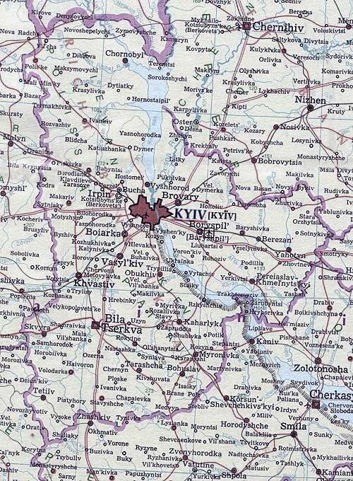
Kyiv oblast [Київська область; Kyivska oblast]. An administrative region in north-central Ukraine on both banks of the Dnipro River, formed on 27 February 1932. After 1939 it relinquished its western territory to a new Zhytomyr oblast and in 1954 a slice of its southern territory to accommodate the new Cherkasy oblast. Presently Kyiv oblast, excluding the city of Kyiv, occupies 28,131 sq km and a population of 1,754,300 (2018). Administratively, it is divided among 25 raions, 26 cities, 30 towns (smt) and 1,126 villages. Both the oblast capital and national capital is Kyiv.
Physical geography. Kyiv oblast is located on the rolling plain of the middle Dnipro Basin. It may be divided into three parts. Its northern part lies in the Polisia Lowland (elevation up to 198 m). It consists of gently rolling moraine, alluvial fan and lake deposits, covered with coniferous and mixed forests, and marshes, on soddy-podzolized, gley, meadow, and marshy soils. The second part rises in elevation from the Dnipro River to the southwest to form the Dnipro Upland. It is a loess-covered gently undulating plain, incised by rivers, attaining maximum elevation of 273 m in the south. Its northern transition belt west of Kyiv has gray forest soils and podzolized chernozems; further south deep typical chernozems prevail. Natural vegetation is of the forest-steppe. The third part is east of the Dnipro River, forming the Dnipro Lowland. The surface is nearly flat, the terraces defined by sandy rises with marshy troughs in between. The second terrace (145 m) is dissected by gullies near rivers or contains gentle depressions where internal drainage causes saline ponding. Soils include soddy-podzolized, gley, meadow, marshy and peat bog soils in the low wetlands, podzolized chernozems and typical chernozems on the second terrace with saline soils in depressions. Forests cover 624,100 ha (23.7 percent) of the oblast’s land area.
The climate is temperate-continental, with an average temperature of –6°C in January and 19.5°C in July. The annual precipitation is 500–600 mm, decreasing to 400–500 mm in the south. The frost-free season is 160–165 days, and the average growing season (with average daily temperature above 10̊ C) is 155–165 days. The oblast has 177 rivers with lengths over 10 km; the principal ones are the Dnipro River, with its right bank tributaries: the Prypiat River, Teteriv River, Irpin River, Stuhna River, and Ros River, and its left bank tributaries, the Desna River, Trubizh River, and Supii River. In addition to the large Kyiv Reservoir and Kaniv Reservoir on the Dnipro River, there are 11 other water reservoirs, 2,000 ponds, and 750 small flood plain lakes in the oblast. Water bodies occupy about 173,800 ha (6.2 percent) of the oblast’s territory.
History. The oblast’s territory has been populated since late Paleolithic Period (see, for example, Kyrylivska archeological site and Dobranichivka archeological site). From the 9th to the 14th centuries it constituted parts of Kyiv principality and Pereiaslav principality of Kyivan Rus’. From ca 1362 to 1569 it was ruled by Lithuania, from 1471 as part of Kyiv voivodeship. Under Polish rule from 1569, rebellions of Cossacks took place there in the late 16th and early 17th centuries. From 1648 to 1667 it was part of Kyiv regiment in the Hetman state. With the Treaty of Andrusovo Right-Bank Ukraine (except Kyiv) remained under Poland, while Left-Bank Ukraine and Kyiv came under Muscovite rule. Semen Palii’s rebellion (1702–4) and haidamaka uprisings occurred in Right-Bank Ukraine in the 18th century. The Cossack Kyiv regiment existed in Left-Bank Ukraine until 1781. During the partitions of Poland in the late 18th century, all of Right-Bank Ukraine was annexed by the Russian Empire, and the oblast’s territory there made up a large part of Kyiv gubernia (1797–1925).
Under Soviet rule, Kyiv gubernia was abolished in 1925, and its territory became part of Kyiv, Cherkasy, Bila Tserkva, Berdychiv, Zhytomyr, and Korosten okruhas. Kyiv oblast replaced the okruhas in February 1932; at that time the oblast incorporated a large part of Right-Bank Ukraine, including Soviet-ruled Volhynia (now Zhytomyr oblast). Some of its raions became part of the new Zhytomyr oblast and Poltava oblast in 1937, Vinnytsia oblast and Kirovohrad oblast in 1939, and Cherkasy oblast in 1954.
Population. In 1939 the population of the oblast within its present-day borders was 1,715,900 without Kyiv and 2,562,600 with Kyiv. Because of high mortality (including the destruction of many thousands of Jews in the Nazi Holocaust) during the Second World War, the population living outside Kyiv recovered only by 1959 to 1,719,000. The city of Kyiv, however, has constantly attracted people from the oblast around it, from other parts of Ukraine and elsewhere, and its population has grown by 1959 to 1,104,300. Some of this growth spilled over into Kyiv’s satellite towns and cities of Kyiv oblast. Thus the population of Kyiv oblast grew from 1,836,000 in 1970 to 1,923,900 in 1979 and peaked at 1,947,600 in 1990. Its subsequent decline to 1,843,400 (2001) and 1,754,300 (2018), with an accelerating decline in rural population 1,053,200 (1979), 888,800 (1990), 783,700 (2001) and 665,100 (2018) without compensating growth in urban population 870,700 (1979), 1,058,800 (1990), 1,059,700 (2001) and 1,089,200 (2018), was driven by death rates exceeding birth rates, first in rural, then after 1993 also in urban areas. The Chornobyl nuclear disaster of April 1986, that took place near the northern border of Kyiv oblast with Belarus, led to the evacuation of the nearby cities of Prypiat and Chornobyl, the towns of Poliske and Vilcha, and 74 villages in the two northernmost raions, mostly to areas beyond Kyiv oblast. The Prypiat residents, who continued to work at the nuclear power station, were re-settled in the new city of Slavutych (45 km east of Prypiat, across the Dnipro River), forming an exclave of Kyiv oblast within Chernihiv oblast, and thus were counted as residents of Kyiv oblast. Evacuations elsewhere, however, caused a slight dip in population of the oblast in 1988.
In contrast to the more cosmopolitan city of Kyiv, Ukrainians constituted 93.2 percent of the population of Kyiv oblast in 1959, their share dropping to 90.5 percent in 1979 and 89.4 percent in 1989, but recovering to 92.5 percent in 2001; the share of Russians increased from 4.8 percent in 1959 to 8.4 percent in 1979, 8.7 percent in 1989 and then declined to 6.0 percent in 2001; the share of Jews declined constantly, from 0.9 percent in 1959 to 0.1 percent in 2001, as did the share of Poles, from 0.4 percent in 1959 to 0.2 percent in 2001. There were 13 cities in Kyiv oblast with populations over 20,000 in 2018: Bila Tserkva (209,200), Fastiv (46,300), Pereiaslav (27,300), Slavutych (25,000) and, within 25 km commuting distance to Kyiv, Brovary (103,800), Boryspil (61,800), Irpin (53,400), Vyshneve (39,900), Vasylkiv (37,800), Boiarka (35,400), Bucha (33,900), Obukhiv (33,100), and Vyshhorod (29,100). Although the largest concentration of scientific and learning institutions are located in the city of Kyiv, Kyiv oblast also had 26 vocational-technical schools with 8,400 students and 21 postsecondary institutions with 27,600 students. These include the Pereiaslav-Khmelnytskyi State Pedagogical University and the Bila Tserkva National Agrarian University.
Economy. Kyiv oblast is a major industrial-agrarian region of Ukraine. Industry has grown during the Soviet period, notably in Kyiv, stagnated in 1990 and re-structured since 1991. Agriculture remains important in the oblast’s economy. It is varied and intensive, with an emphasis on grain, potatoes, sugar beets, meat, and dairy products. The service sector, including trade, financial services, transport and communications, have grown in importance. In 2018, to the gross regional product of the oblast, industry contributed 22 percent, trade 16 percent, agriculture 14 percent, financial services 8 percent, transport and communications 9 percent.
Industry. In 1940 there were 797 large industrial enterprises in the oblast (including Kyiv), which employed 210,000 workers and produced 12 percent of Soviet Ukraine’s industrial output. Since the Second World War industry has been reconstructed and expanded. Much of it was and is concentrated in Kyiv. By 2009 Kyiv accounted for 14.2 percent of Ukraine’s industrial production and services, by value, whereas Kyiv oblast’s share was 3.8 percent.
With the collapse of Soviet centralized planning, industrial enterprises lost funding, state orders and underwent restructuring. By 1992 there were 647 large self-managed industrial enterprises, of which 330 were in Kyiv and 317 in Kyiv oblast. The total increased to 842 in 2000, of which 484 were in Kyiv and 358 in Kyiv oblast. By 2010 registered industrial businesses increased to 20,617 in Kyiv and 5,812 in Kyiv oblast.
The major branches of industry in Kyiv oblast in 1984 were machine building and metalworking industry (22 percent of the oblast’s total industrial output), food production (21.1 percent), energy production (13.9 percent), light industry (12.3 percent), and chemicals and petrochemicals manufacturing (10.5 percent). By 2018 food processing became the leading branch (28.4 percent), followed by energy production (18.5 percent). The declining machine-building and metalworking (17.0 percent) was now matched by plastics, rubber and chemicals (16.5 percent), followed by woodworking, paper and printing (9.4 percent), electric equipment and electronics (1.8 percent). Light industry declined to 0.6 percent.
Kyiv oblast’s industries are powered by the Kyiv Hydroelectric Station and the Kyiv Water-Accumulating Electric Station at Vyshhorod, and the Trypillia Thermal Electric Power Station at Ukrainka, fueled by anthracite coal from Donbas. The Chornobyl Nuclear Electric Station continued to provide energy following the nuclear disaster there in April 1986 until its closure in December 2000. In Bila Tserkva a small thermal-electric co-generating station powered by oil or gas supports the needs of that city. Within Kyiv, the two largest capacity thermal-electric co-generating power stations in the oblast, 5 and 6, burn natural gas.
The food industry of the oblast consists of sugar-beet processing (16 plants in Bila Tserkva, Hrebinky, Myronivka, Rokytne, Yahotyn, Zhurivka, and elsewhere), dairy-products manufacturing (30 plants), distilling (5, including Stadnytsia, Chervona Sloboda, Tkhorivka, and Trylisy), brewing (3 large and 10 craft breweries in Kyiv, and one large in Brovary, Fastiv and Khotyanivka), non-alcoholic beverage production (6 plants), 77 meat packing and 24 vegetable and fruit canning plants (the largest in Bila Tserkva). Supplying the agricultural sector are 21 animal-feed plants in the oblast. The largest concentration of food processing, not included in the oblast total, is located in Kyiv, with an emphasis on baking and dairy.
The main machine-building and metalworking industries of the oblast are located in Bila Tserkva (electrotechnical equipment, agricultural machines), Borodianka (excavators), Brovary (mobile cranes, food-industry and lighting equipment), Fastiv (electrotechnical and chemical-industry equipment), Hrebinky (food-industry equipment), Irpin (peat-extraction machinery), Rzhyshchiv (sanitation-technology equipment), and Vasylkiv (gas equipment, refrigerators, electric irons, and other appliances). A large powder-metallurgy plant is located in Brovary. Kyiv, not in the oblast total, is the largest and most varied machine-building center.
The main oblast centers of the chemical industry and petrochemical industry are Bila Tserkva (2 tire plants, asbestos technical products), Brovary (tire repairs, rubber and asbestos products, plastics), and Trypillia (biochemicals). Pharmaceuticals and biochemical preparations are made in Nemishaieve. Kyiv, though not included in the oblast total, has the largest and most varied concentration of chemical industry (paints, pharmaceutical, plastics, rubber-asbestos, soda and acids, synthetic fibres).
Building materials produced in the oblast include reinforced-concrete products (in Bila Tserkva, Boryspil, Brovary, Rokytne, and Vyshhorod), bricks (in Staiky, Bila Tserkva, and Bucha), granite products (in Bucha), and glass (in Babyntsi, Bucha, Piskivka, and Hostomel). Granite is quarried near Bohuslav and Bila Tserkva. Kyiv, not included in the oblast total, is the largest producer of reinforced-concrete products and wall materials.
Woodprocessing is represented by cellulose and papermaking (in Borova, Fastiv and Obukhiv) as well as milling and making of wood products, such as inlaid floors and furniture; furniture making is located in Brovary, Bila Tserkva, Fastiv, Irpin, and Komarivka. The city of Kyiv, while not part of the oblast total, is the largest producer of wood-derived products.
The oblast’s light industry consists mainly of the manufacturing of woolen textiles (in Bohuslav and Berezan), clothing (Fastiv, Pereiaslav, Skvyra), knitwear (Bila Tserkva, Brovary), leather goods and footwear (Baryshivka, Bila Tserkva, and Vasylkiv), and linen (in Makariv, but abandoned in Ivankiv and Poliske). The city of Kyiv, not included in the oblast total, produces more textiles, clothing and footwear than the oblast by itself.
Agriculture. Kyiv oblast contributes the largest share (6.5 percent) of Ukraine’s agricultural production by value. It ranks fourth (5.6 percent) in crop production but first (8 percent) in animal husbandry.
Collective and state farms were replaced, after 1991, by commercial family farms, farming associations and corporate farms, based mainly on renting farmland. Whereas in 1985 there were 283 collective farms and 164 state farms in the oblast, they were replaced by 2009 with 2213 agricultural enterprises of different types: 1,474 commercial family farms, 436 farm corporations, 157 private farm enterprises, 47 farm co-operatives, 44 state farms and 55 other farming enterprises. Rural households, however, continue to practice subsistence gardening and subsidiary animal husbandry.
In 1985 the collective farms and state farms had at their disposal 2,057,000 ha, of which 1,771,000 ha were used directly in agriculture; of the latter, 84.1 percent was tilled, 7.1 percent was hayfield, and 6.7 percent was pasture. Irrigated land amounted to 113,600 ha and drained land, to 161,900 ha. The main crops cultivated were high-quality grains (particularly winter wheat) and sugar beets in the forest-steppe raions, potatoes and long-staple flax (dovhunets) in the regions in Polisia, vegetables, berries, and fruits.
Following the Chornobyl nuclear disaster in April 1986 and the resultant contamination of land with radionuclides, settlements in the northern part of Kyiv oblast around Chornobyl and to the north and west of it were abandoned. The Chornobyl Exclusion Zone was established and then expanded to cover about 260,000 ha of forests, wetlands, meadows and some abandoned cropland. As a result, agricultural land used by agricultural enterprises in Kyiv oblast was reduced from 1,771,000 ha in 1984 to 1,705,000 ha in 1987 and to 1,641,000 ha in 1994 (to 92.7 percent of area in 1984), a reduction of 130,000 ha; cultivated land declined from 1,488,000 ha in 1984 to 1,450,000 ha in 1987 and 1,387,000 ha in 1994 (93.2 percent of its area in 1984); hayfields and pastures, from 244,000 ha to 218,000 ha and 209,000 ha, respectively (to 85.7 percent of their area in 1984).
Beyond the exclusion zone, in affected parts of Kyiv oblast, cropping patterns were modified to minimize the contamination of food. This consideration as well as changing economic conditions resulted in some changes to farming practices, crops grown and animals kept.
In 1975 the sown area in Kyiv oblast occupied 1,467,700 ha. Grains dominated with 735,800 ha (50.1 percent) of the oblast’s sown area; among them were winter wheat, 334,000 ha (22.8 percent), spring barley, 150,900 ha (10.3 percent), corn for grain, 43,600 (3.0 percent) and buckwheat, 19,900 (1.4 percent). Fodder crops occupied 423,000 ha (28.8 percent of the tilled land) in 1975, of which corn for silage (11.2 percent in 1971), and grasses and legumes (8.3 percent in 1971) were most important. In this near urban setting, potatoes, 136,700 ha (9.3 percent) and vegetables, 28,800 ha (2.0 percent) were well represented. Industrial crops were primarily sugar beets, 120,200 ha (8.2 percent), but flax, 12,100 ha (0.8 percent) and sunflowers, 2,500 ha (0.5 percent) were also grown. In 1975 berry crops and fruit orchards occupied 50,800 ha of land, of which 40,000 ha were productive.
By 1994 the sown area in Kyiv oblast declined to 1,339,000 ha. Grains declined to 536,000 ha (40.0 percent of the area sown), while fodder crops increased to 550,000 ha (41.1 percent of the sown area). Potatoes and vegetables retained their prominent place at 131,000 ha (9.8 percent of the sown area) while industrial crops receded to 122,000 ha (9.1 percent of the sown area); they were mostly sugar beets (104,500 ha in 1995), some sunflower (7,900 ha in 1995) but very little flax). Berry crops and fruit plantings declined significantly by 1995 to 37,600 ha.
Sown area in Kyiv oblast continued to decline each year until 2009, when it reached 1,101,500 ha, and then began to recover again. In 2017 the total sown area was 1,183,800 ha of which 589,700 ha were in grains. Of the industrial crops, the area sown to sugar beets declined to 21,500 ha while that of the more profitable sunflowers grew to 166,300 ha. Potatoes (94,500 ha) and vegetables (28,700 ha) retained their position. Berry crops and fruit plantings continued to decline in area to 9,300 ha.
Crop yields fluctuated from year to year, but showed significant increase from the 1960s and again since 2005. Average yields of grains, in centners per hectare, increased from 21.8 (1960–74) to 28.6 (1990–2004), and 45.7 (2005–18); of sugar beets, from 276 (1960–74) and 238 (1990–2004) to 422 (2005–18); of sunflowers, from 12.5 (1960–74) and 10.1 (1990–2004) to 21.7 (2005–18), of potatoes, from 108 (1960–74) to 127 (1990–2004) and 162 (2005–18), of vegetables, from 124 (1960-1974), to 135 (1990-2004) and 206 (2005-2018), and of fruit and berries, from 34.8 (1960–74) and 22.5 (1990–2004) to 58.9 (2005–18).
Animal husbandry is highly developed in Kyiv oblast, ranking first among the oblasts of Ukraine. Within Kyiv oblast, animal husbandry accounted for 54 percent of the total value of agricultural output in 1983 and 55 percent in 1990, but diminished to 46 percent by 2000 and 36 percent in 2018. In the raions in Polisia it consists of some cattle farming (much of it abandoned after the Chornobyl nuclear disaster contamination of pastures). In the forest-steppe raions the animals raised are mostly hogs (853,200 head in 1990, 553,500 head in 2000, 496,100 head in 2018), ranking first among the oblasts of Ukraine, and cattle (1,307,800 head in 1990, 501,700 head in 2000, and 121,900 head in 2018). Of the cattle, about one-half are milk cows (473,500 in 1990, 262,200 in 2000, and 62,500 in 2018), of which nearly one-half are still kept by rural households, in part for home consumption. Poultry farming (fowl in millions, 15.9 in 1990, 9.0 in 2000, and 29.5 in 2018) is now largely commercial. Of the 21 large state poultry factories that were privatized and modernized, the largest, in Myronivka, is owned by the billionaire Yurii Kosiuk. Kyiv oblast is by far the largest producer of poultry meat and eggs in Ukraine. Auxiliary household enterprises include the keeping of goats and sheep (79,700 in 1990, 43,900 in 2000, and 30,500 in 2018), beekeeping, and rabbit and fish farming.
Transportation. Railways, roads, rivers and pipelines form the oblast’s transport network. The length of effective railroads is 756 km (2009), down from 880 km (1983–90). The main lines crossing the oblast are Moscow–Kyiv–Odesa (double-track, electrified), Kyiv–Lviv (double-track, electrified), Kyiv–Sarny–Kovel (mostly single-track), Kyiv–Sumy–Kharkiv (double-track), Kyiv–Poltava (double-track), and Kyiv–Dnipro–Donetsk (double-track, electrified). The main junctions in Kyiv oblast are Kyiv, Fastiv, and Myronivka. There are 8,500 km (2009) of motor roads in Kyiv oblast, all of which are paved, an increase from 8,100 km in 1990, of which 7,900 were paved. The main highways from Kyiv, numbered in clockwise order, are Kyiv–Chernihiv–Homel–Saint Petersburg (M-01), Kyiv–Briansk–Moscow (M-02), Kyiv–Poltava–Kharkiv (M-03), Kyiv–Dnipro–Donetsk–Luhansk (M-04), Kyiv–Odesa (M-05), Kyiv–Lviv (M-06) and Kyiv–Kovel–Lublin–Warsaw (M-07). River transportation on the Dnipro River, Desna River, Prypiat River, and part of the Teteriv River is well developed, but has declined in importance. Airports are located in Boryspil (Kyiv’s main international airport), Hostomel (air freight airport, northwest of Kyiv), Sviatoshyn (Antonov aircraft assembly plant, within northwest perimeter of Kyiv), Zhuliany (Kyiv’s city international airport, within Kyiv), Bila Tserkva (former bomber air base, now aircraft repair depot, considered for conversion to air freight airport), and Vasylkiv (military interceptor air base).
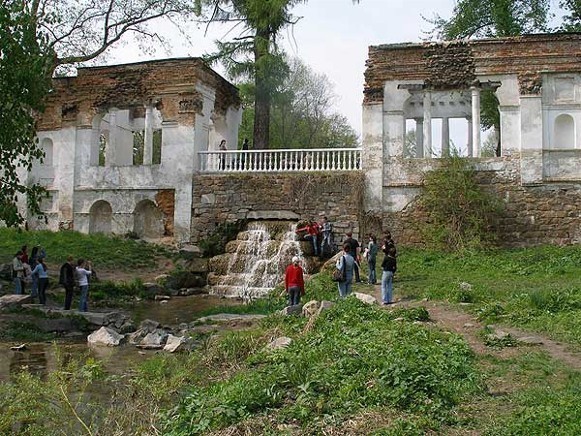
Tourism. Beyond Kyiv, some tourists are attracted to Kyiv oblast to see its historic cities of Pereiaslav, Bila Tserkva (formerly Yuriiev of the Princely era), and Vyshhorod, with their churches and museums. Natural attractions include the Kyiv Reservoir, the Biloozerskyi National Nature Park (established in 2009, 7,000 ha) in the Pereiaslav-Khmelnytskyi raion, the Zalissia National Nature Park (established in 2009, 14,800 ha) in the Brovary raion, and the Oleksandria Dendrological Park in Bila Tserkva. Tours of the Chornobyl Exclusion Zone to see the secured nuclear power station and the abandoned city of Prypiat have gained popularity. Tourists in Kyiv oblast serviced by tourist agents reached 66,400 in 2018, of which only 40 were from abroad. There were 56 hotels in Kyiv oblast in 2010.
BIBLIOGRAPHY
Starovoitenko, I. Kyïvs'ka oblast' (Kyiv 1967)
Rudych, F.; et al (eds). Istoriia mist i sil Ukraïns'koï RSR: Kyïvs'ka oblast' (Kyiv 1971)
Pryroda Kyïvs'koï oblasti (Kyiv 1972)
Kharchenko, A. (ed). Atlas Kievskoi oblasti (Moscow 1985)
‘Kyivs'ka oblast'’ in Heohrafichna entsyklopediia Ukraïny. Vol. 2 (Kyiv 1990)
Kyivs'ka oblast'. Polityko-administratyvna karta 1:250,000 (Kyiv 2002)
Kompleksnyi atlas Kyivs'koi oblasti (Kyiv 2009)
‘Kyivs'ka oblast'’ Statystychnyi atlas rehioniv Ukrainy (Kyiv 2018) http://www.ukrstat.gov.ua/
Ihor Stebelsky
[A new version of this article was written in 2019.]
.jpg)
.jpg)

.jpg)
.jpg)
.jpg)