Boh River
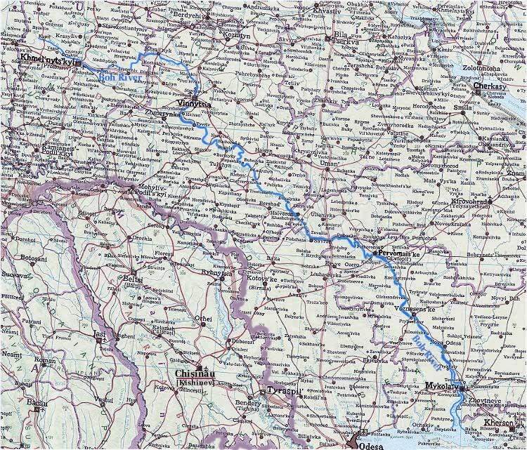
Boh River (ancient Greek: Hipanis; now called Buh Pivdennyi or Pivdennyi Buh [Southern Buh] in Ukraine to differentiate it from the Buh River, a tributary of the Vistula River and now called Zakhidnyi Buh [Western Buh]). One of the largest rivers of Ukraine, 857 km in length (792 km to the liman). Its drainage basin covers an area of 63,740 sq km (including the Inhul River, which empties into the Boh Liman). In its upper section in the Podolian Upland the Boh flows slowly through a wide, muddy valley (slope: 0.37 m/km). Its middle section cuts into a crystalline massif, and the gradient increases (up to 0.92 m/km) as it flows between craggy banks. Rapids appear and are most concentrated in the 70 km stretch between the town of Pervomaisk and the village of Oleksandrivka (Mykolaiv oblast), where the steep banks reach a height of 90 m (here the Myheiski, Bohdanivski, and other rapids are found). Below the rapids the river flows through Tertiary limestone and sandstone of the Black Sea Lowland. It spreads out to 800 m (2–3 m deep) and enters the deep Dnipro-Boh Estuary near the town of Nova Odesa. Atmospheric precipitation (rain and snow) serves as the main source of water for the Boh. The Boh's water volume varies significantly throughout the year. The Boh generally freezes in December and thaws in March, but these conditions do not always prevail. The Boh's tributary system is poorly developed, especially on the right bank, because most of Podilia's rivers flow into the Dnister River. The right-bank tributaries of the Boh are the Vovk River, Zhar River, Riv River, Savranka River, Kodyma River, and Chychykliia River. The left-bank tributaries are the Bozhok River, Snyvoda River, Sob River, Syniukha River with Hirnyi Tikych River, Mertvovid River, and Inhul River (the largest tributary).
Because of the rapids, uneven gradient, and small water volume, only the lower Boh is navigable, from the town of Voznesensk to the Black Sea (156 km). The river is open to navigation for about 250 days of the year. The main ports are Voznesensk and Mykolaiv, and the cargo consists mostly of grain and building materials. The middle section of the river has large hydroelectric resources (101,038 kW), which so far remain largely unused. The main cities located on the Boh are Khmelnytskyi, Vinnytsia, Pervomaisk, and Mykolaiv.
Volodymyr Kubijovyč


.jpg)

